I love to go a-wandering off the beaten track,
and as I go, I love to sing, my knapsack on my back.
Val-di-ree, Val-di-rah,
Val-di-ree, Val-di-rah-ha-ha-ha-ha-ha-ha
Val-di-ree, Val-di-rah,
My knapsack on my back.

Monday, August 28, 2017

Skyline Trail, August 21-26, 2017

Hiked the Skyline Trail in ONP. It climbs up the ridge between the Quinault River and the Queets River, traversing some spectacular alpine scenery. A primitive trail in rugged terrain, it doesn't get much use and is no longer maintained. Wore me out completely. 51.4 miles, 10,000 feet (!) elevation gain.

I left Silverdale right after church, had lunch in Aberdeen and arrived at the Quinault Ranger Station about 3 pm and got my permit. Drove to the trailhead and started hiking at 4. I looked pretty chipper when I started at the trailhead on the North Fork of the Quinault River.

Arrived at Big Creek about 7 pm. It was cool and shady down in the bottom of the canyon. Found a nice spot on a gravel bar for my camp.

 
On Monday morning, I started up the trail during the eclipse. Not too noticeable, but there was an eerie shadow for a while.  Pleasant hiking past Three Lakes Camp.

Monday night I camped at Three Prune Camp where I was joined by five hikers about my age. A fascinating tribe of kindred souls. They invited me for a drink and we had a gabfest. 

Tuesday morning. The trail goes higher and higher up the ridge through alpine meadows.
 
 I stopped for lunch at the divide between the Quinault River and the Queets River. Looking down into the Queets
, you can see the dead trees from the 2015 Paradise fire.


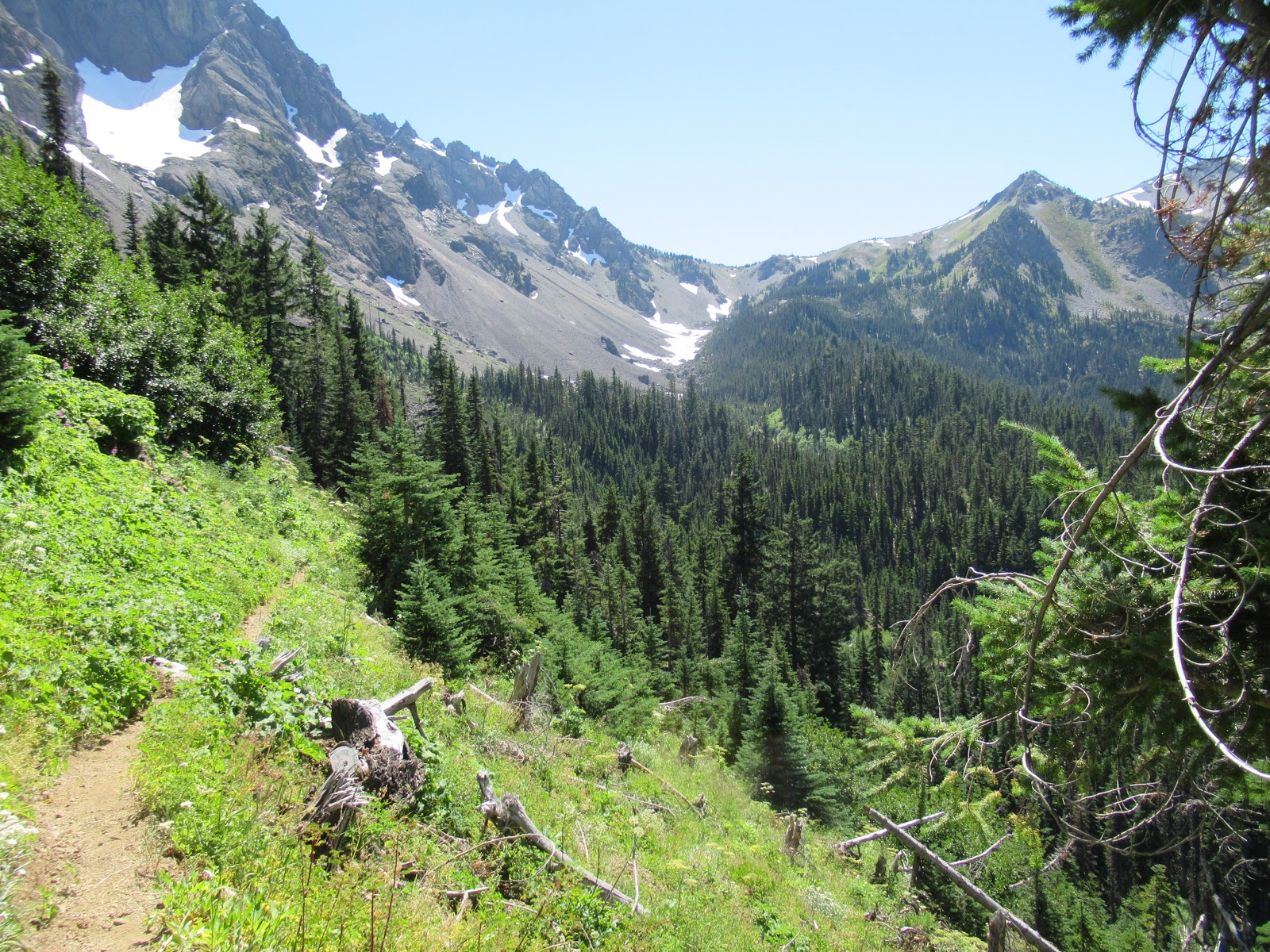
Traversing below Kimta peak. The trail in this section is rocky, steep and crumbling. 

 More traversing below Kimta Peak.

 Can you see the elk bedded down in the meadow? 

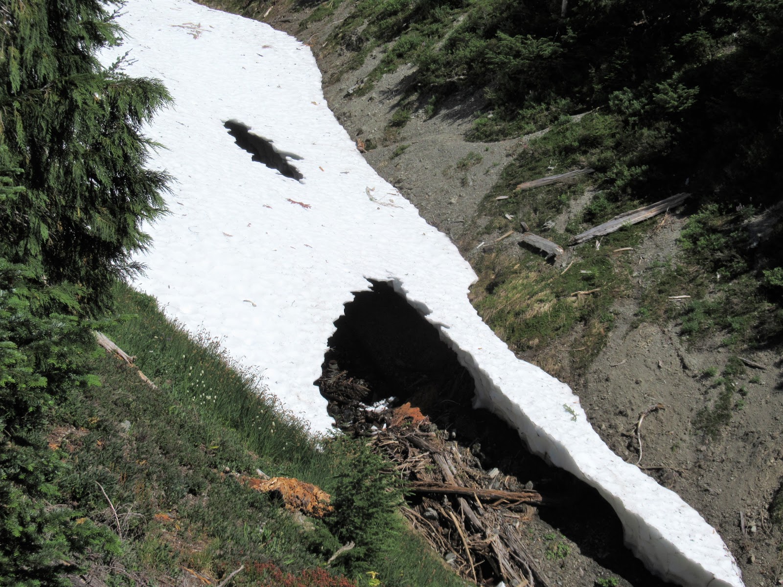
Where should I cross this snowbridge? I skittered across far above the scary black hole.


An old burn near Promise Creek Pass. 


I arrived at Promise Creek Pass at 5 pm, totally worn out. I abandoned my plan to continue to Lake Beauty and found this pretty spot below the trail. Unfortunately, the mosquitoes were the worst I've ever experienced. Torture. 
On Wednesday morning, the mosquitoes were already divebombing at 6 am, so I got up and hiked to the top of the ridge where the breeze kept them off. Ate my muesli while I looked across at Mount Olympus.

Passed a pretty tarn in a section called the Moonscape. 

The Moonscape is barren rock and scree, and the only way to find the route is to follow rock cairns that show the way. Eerie and beautiful. 

After several hours of traversing a series of v-notch canyons that required going down very steeply, then up very steeply, I arrived at Lake Beauty. Mount Olympus is beyond. 

The trail goes down to Seattle Creek, then up to the rolling meadows on the shoulder of Mt. Seattle. I was exhausted at the end of this 13 hour day. 

The campsite at Low Divide was blessedly welcoming. Three guys nearby provided good company. 

On Thursday, I took a day hike to Martins Lakes so I could say I did. Another thousand feet of elevation gain to get to a very pretty setting. Four Boy Scouts joined me at this lake, providing entertainment for me. One of them went swimming in the lake. 

On Friday it was just a matter of hiking 15. 7 miles out the Quinault River. This is the ford at 16-mile Camp. It was about knee-deep at 10 in the morning and I crossed easily. 

One weary traveler back at the trailhead on Saturday morning. This hike was way tougher than I anticipated. It kicked my butt. I'm glad I did it, but I'm not doing it again! 


Tuesday, August 1, 2017

Home Lake and Del Monte Ridge, July 31 - August 1, 2017

A lovely two-day hike up the Dungeness River to Constance Pass and Del Monte Ridge. Great weather, abundant flowers, and terrific views.

I had hoped to leave home Sunday afternoon and hike to Camp Handy Sunday night, but I was reluctant to leave because my parishioner John Steller was near death. I had visited several times and anointed him with oil the day before, but I didn't want it to look like I was abandoning him and his family. I talked with his wife, Janet, and she assured me I should go. I contacted Dick Scott, a retired priest, and he said he'd be glad to visit at the time of death. So I felt free to go on Monday morning.

I left home at 7:15 am and started hiking at the Dungeness River trailhead at 9:00. The morning was cool and pleasant and the first few miles reeled off easily.


I love the grove of huge firs on the lower part of the trail.


A photo taken with the camera timer.

By mid-morning I was sweating up the inclined trail to Boulder Shelter. Three vigorous and fit women in their fifties passed me at the river crossing. Two women in their seventies passed me, then I passed them. Then a group of five hikers passed me while I was resting. When they stopped for lunch I pulled ahead of them and kept going. Quite crowded on the trail.

\As I approached Boulder Shelter, I started seeing wildflowers. They were out in full force this time of year. These are harebells.

A field of flowers near Boulder Shelter.


As I progressed up the valley, the trail eased up and I began to see ahead to the skyline and the pass. I was quite tired by mid-afternoon and went slowly. I crossed a rocky-strewn slope and entered the last incline to Home Lake. I arrived about 4:00. I met a man in his fifties and his teenage daughter who were camping at the lake and had a pleasant conversation.


As the sun was setting, the side of Mount Constance began to glow with sunlight. I grabbed my watercolors and made this painting, swatting away mosquitoes as I painted:


My camp overlooking Home Lake.

As the sun began to set, the alpenglow on the ridge to the East was lovely.

The next morning I awoke by 6:00, had breakfast, and started up to the pass by 7:00. There were flowers everywhere.

Switchbacks on the way up to the pass.

 At Constance Pass.

Looking off to the South, I could see the back side of The Brothers.

From the pass, I continued up the ridge, with the views increasing at every step. It's wide open tundra, easy going.

From the ridge, I could see the entire Dosewallips drainage including Anderson Pass, Lost Pass, and Hayden Pass. Grey Wolf Pass was hidden behind the ridge, but I could look down on all the trails I have hiked.


Wandering in the alpine. I felt free and elated to be in the high country.

Fields of flowers.

"The joy of the universe came rushing to meet me and I embraced here. Yes, yes O yes!

I started down the moutain and arrived at my camp at 9:20. I took a half hour break and started out at 9:50.

Home Lake see from above. You can just see the first wisps of smoke coming into our area from the fires in Canada. The smoke would last for a week before it cleared away.

There were fields of flowers on the way out.

Big flowers against a dark background.

Had lunch at Boulder Shelter and continued down the trail This is just below Boulder Shelter. Returned to the car at 4:10 and drove home, stopping for ice cream and coffee.