I love to go a-wandering off the beaten track,
and as I go, I love to sing, my knapsack on my back.
Val-di-ree, Val-di-rah,
Val-di-ree, Val-di-rah-ha-ha-ha-ha-ha-ha
Val-di-ree, Val-di-rah,
My knapsack on my back.
Showing posts with label Dungeness. Show all posts

Friday, June 24, 2022

Up the Dungeness River to Boulder Shelter

Friday, June 24, 2022 - 12.6 miles and 2,000 feet elevation gain

I left the house at 6:30 am and started hiking at the trailhead at 8:45. It was a beautiful day for hiking -- cool and clear all day. The air felt cold as I headed up the Dungeness River trail, but I warmed up as I strode along. It felt good to be hiking. 

The big firs on the lower trail

Footbridge over the Dungeness River

 I got to Royal Creek in twenty minutes and I arrived at the footbridge at 9:45, exactly one hour. Took a ten minute break and met a photographer coming down the trail. He was hoping to photograph the rhododendron blossoms, but they were still in tight little buds.

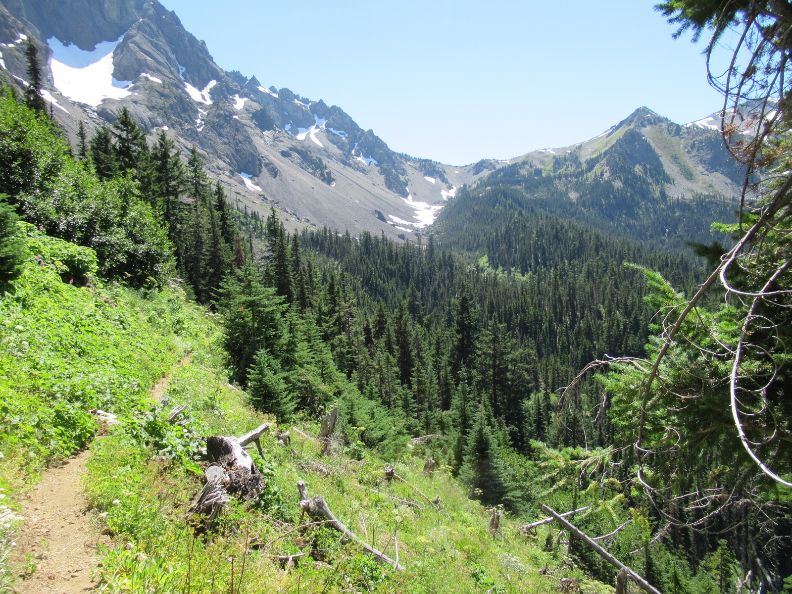
Hiked past Camp Handy and started into the steep section of the trail. I felt surprisingly strong and took very few breaks. When I got tired, I just slowed my pace a little. Took a break after another hour. The last mile and a half to Boulder Shelter always seems to take forever because there are no landmarks.


 Finally I reached some good views across the valley and not long after that I emerged into the meadows at Boulder Shelter.

The boulders at Boulder Shelter

I leaned my back against a small boulder and enjoyed a leisurely lunch of peanut butter and crackers, raisins and cheese, chocolate, and an orange. Drifted off into a nice nap in the warm sun.

I woke up at the sound of hiker's voices and decided to pack up and leave. I made my way back down the trail at a leisurely pace, daydreaming as I went. The miles seemed to fly by, and I got to the trailhead at 4:15. Stopped at Camp Handy for a break on the way back.

I was really pleased to find that I'm in pretty good shape. My left big toe, which has bothered me in the past, gave me no trouble at all.

Friday, June 26, 2020

Boulder Shelter June 26, 2020

Hike to Boulder Shelter
June 26, 2020
12 miles, 2,750 feet elevation gain

Guy and I got up early and drove up the Dungeness River to the trailhead, arriving about 8:00. It was a beautiful day, nice and cool in the morning underneath the big trees. 


We hiked steadily up to Camp Handy, where we stopped for a break and some trail mix. We explored the campsites a little bit. Two women and their four kids were camped along the river, singing in and playing games. Kind of sweet.

We decided to go a little further, and continued up the trail as it gains elevation. Stopped at noon for lunch. Afterwards I said to Guy, “I think we’re only about twenty or thirty minutes from Boulder Shelter. Want to try to reach it?” He decided to rest, and I took off for the shelter. It actually took me more like 33 minutes to get there, but I made it. It felt good to push myself and see if I could keep up a good pace on the trail. 
Meadow at Boulder Shelter

Looking out at the upper Dungeness River valley
 
I returned to Guy who was patiently waiting for me and we started back to the car. There was a nice breeze in our faces as we hiked down the valley. Go back about 4:00, home by dinner.

For this hike I bought new insoles for my boots to replace the worn Dr. Scholl’s insoles. The new ones seemed quite a bit better, with more padding under my feet. My feet were tired, but much better than last week’s hike up Mt. Townsend.

Tuesday, August 1, 2017

Home Lake and Del Monte Ridge, July 31 - August 1, 2017

A lovely two-day hike up the Dungeness River to Constance Pass and Del Monte Ridge. Great weather, abundant flowers, and terrific views.

I had hoped to leave home Sunday afternoon and hike to Camp Handy Sunday night, but I was reluctant to leave because my parishioner John Steller was near death. I had visited several times and anointed him with oil the day before, but I didn't want it to look like I was abandoning him and his family. I talked with his wife, Janet, and she assured me I should go. I contacted Dick Scott, a retired priest, and he said he'd be glad to visit at the time of death. So I felt free to go on Monday morning.

I left home at 7:15 am and started hiking at the Dungeness River trailhead at 9:00. The morning was cool and pleasant and the first few miles reeled off easily.


I love the grove of huge firs on the lower part of the trail.


A photo taken with the camera timer.

By mid-morning I was sweating up the inclined trail to Boulder Shelter. Three vigorous and fit women in their fifties passed me at the river crossing. Two women in their seventies passed me, then I passed them. Then a group of five hikers passed me while I was resting. When they stopped for lunch I pulled ahead of them and kept going. Quite crowded on the trail.

\As I approached Boulder Shelter, I started seeing wildflowers. They were out in full force this time of year. These are harebells.

A field of flowers near Boulder Shelter.


As I progressed up the valley, the trail eased up and I began to see ahead to the skyline and the pass. I was quite tired by mid-afternoon and went slowly. I crossed a rocky-strewn slope and entered the last incline to Home Lake. I arrived about 4:00. I met a man in his fifties and his teenage daughter who were camping at the lake and had a pleasant conversation.


As the sun was setting, the side of Mount Constance began to glow with sunlight. I grabbed my watercolors and made this painting, swatting away mosquitoes as I painted:


My camp overlooking Home Lake.

As the sun began to set, the alpenglow on the ridge to the East was lovely.

The next morning I awoke by 6:00, had breakfast, and started up to the pass by 7:00. There were flowers everywhere.

Switchbacks on the way up to the pass.

 At Constance Pass.

Looking off to the South, I could see the back side of The Brothers.

From the pass, I continued up the ridge, with the views increasing at every step. It's wide open tundra, easy going.

From the ridge, I could see the entire Dosewallips drainage including Anderson Pass, Lost Pass, and Hayden Pass. Grey Wolf Pass was hidden behind the ridge, but I could look down on all the trails I have hiked.


Wandering in the alpine. I felt free and elated to be in the high country.

Fields of flowers.

"The joy of the universe came rushing to meet me and I embraced here. Yes, yes O yes!

I started down the moutain and arrived at my camp at 9:20. I took a half hour break and started out at 9:50.

Home Lake see from above. You can just see the first wisps of smoke coming into our area from the fires in Canada. The smoke would last for a week before it cleared away.

There were fields of flowers on the way out.

Big flowers against a dark background.

Had lunch at Boulder Shelter and continued down the trail This is just below Boulder Shelter. Returned to the car at 4:10 and drove home, stopping for ice cream and coffee.


Friday, July 22, 2016

Treading on clouds, July 22, 2016

I step over passes
with a single stride.
Valleys trail behind me.
I tread on clouds.

After my last meeting on Thursday, I headed out of town at 5:20 pm. I had loaded the car the previous evening. I drove to the Dungeness River trailhead, arriving at 7:15. I set up my tent in the campsite below the road as quickly as I could and then drove up to the Tubal Cain trailhead. I left the car there and started walking on the road back to my campsite. I figured I would get there about 9:15, just as it was getting dark. The skies were cloudy and it was raining lightly.

A small car came by and I put out my thumb. What a surprise! I got a ride back to camp with a cheerful young couple who had just climbed Mt. Townsend. They dropped me off at 8:15, saving me an hour of walking and helping me be fresh for my morning start. During the night there was thunder and lightning up on the ridges, and a couple hours of rain. But I slept well.

I woke up at 5:30, had a quick breakfast of Grape Nuts and milk, and started hiking at 6:00 am. The skies were cloudy and things were wet from the rain. As I started up the trail, it seemed dark and gloomy, even though this is one of my favorite trails.

I arrived at the footbridge over the Dungeness River at 7:00. I have no idea how they moved that enormous tree into place for the bridge, but it is a marvelous crossing.


I continued up the well maintained trail to the Camp Handy shelter, I didn't take time to explore the area, but took a photo from above.


From there the trail climbs steeply up to Boulder Shelter, but the trail is excellent with a good tread. As I got higher, the sky began to open up and I could see the ridges around me. Soon I could see blue sky above with a few clouds on the mountainsides. I arrived at Boulder Shelter a little before 9:30 to find a gentleman about my age drying out his tent. He said he had experienced the thunder and lightning first hand the previous night, and wondered if his time were up. I snapped a photo of the Boulder Shelter and continued on.


After a break sitting in the sun, I continued on the upper trail. It's very steep and I took a lot of breaks. At this point the valleys appear below and you can see across to Mt. Fricaba and Mt. Mystery. It's a glorious panorama that unfolds the higher you get. You can see all the way up Heather Creek.


I arrived at Marmot Pass at 10:45 and took a break. I looked down in the Marmot Pass basin and remembered the two times I'd hiked up here in previous years.


From Marmot Pass, the trail climbs up the ridge. Up to this point I felt strong, but the hours were taking their toll on me, and I began to slow down.

The thunderstorm the previous night laid down about an inch of hail which still lay on the trail. It must have a been a fierce storm because the wind shredded the vegetation and threw it on top of the hail.


 There were still snowbanks to cross.

The final pull up the ridge..


 At 11:40 I arrived at the top of the ridge where there's a great view and a place to rest. This was the high point of my hike, literally and emotionally.


I was a little disappointed to see that I shared the ridge with a young couple who had camped at Buckhorn Lake, and two young women on their way to Home Lake. But I luxuriated in the view and lay down in a place out of the wind for a short nap and something to eat. Here's the view to the west.


At 12:25 I started down the Copper Creek side of the ridge. I could see there was fog laying in the valley and sure enough, the rest of the hike was wrapped in fog.

This deer and I scared each other.

I was tired but I didn't want to stop so I just continued to slog down the mountain. I took one break in the gloomy forest and reached the trailhead and the car at 3:15.

I drove to my camp at the Dungeness River, threw it in the car and arrived home by 6:00, in time for grilled sausages cooked by Guy over the grill.