I love to go a-wandering off the beaten track,
and as I go, I love to sing, my knapsack on my back.
Val-di-ree, Val-di-rah,
Val-di-ree, Val-di-rah-ha-ha-ha-ha-ha-ha
Val-di-ree, Val-di-rah,
My knapsack on my back.

Friday, July 22, 2016

Treading on clouds, July 22, 2016

I step over passes
with a single stride.
Valleys trail behind me.
I tread on clouds.

After my last meeting on Thursday, I headed out of town at 5:20 pm. I had loaded the car the previous evening. I drove to the Dungeness River trailhead, arriving at 7:15. I set up my tent in the campsite below the road as quickly as I could and then drove up to the Tubal Cain trailhead. I left the car there and started walking on the road back to my campsite. I figured I would get there about 9:15, just as it was getting dark. The skies were cloudy and it was raining lightly.

A small car came by and I put out my thumb. What a surprise! I got a ride back to camp with a cheerful young couple who had just climbed Mt. Townsend. They dropped me off at 8:15, saving me an hour of walking and helping me be fresh for my morning start. During the night there was thunder and lightning up on the ridges, and a couple hours of rain. But I slept well.

I woke up at 5:30, had a quick breakfast of Grape Nuts and milk, and started hiking at 6:00 am. The skies were cloudy and things were wet from the rain. As I started up the trail, it seemed dark and gloomy, even though this is one of my favorite trails.

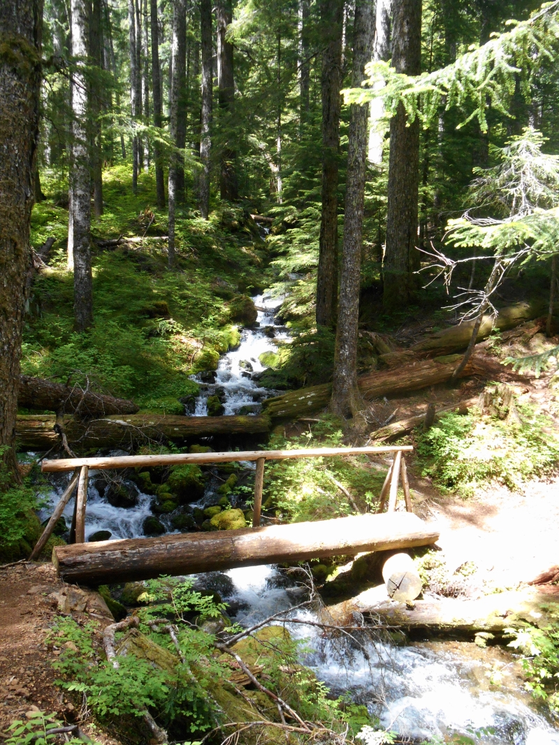
I arrived at the footbridge over the Dungeness River at 7:00. I have no idea how they moved that enormous tree into place for the bridge, but it is a marvelous crossing.


I continued up the well maintained trail to the Camp Handy shelter, I didn't take time to explore the area, but took a photo from above.


From there the trail climbs steeply up to Boulder Shelter, but the trail is excellent with a good tread. As I got higher, the sky began to open up and I could see the ridges around me. Soon I could see blue sky above with a few clouds on the mountainsides. I arrived at Boulder Shelter a little before 9:30 to find a gentleman about my age drying out his tent. He said he had experienced the thunder and lightning first hand the previous night, and wondered if his time were up. I snapped a photo of the Boulder Shelter and continued on.


After a break sitting in the sun, I continued on the upper trail. It's very steep and I took a lot of breaks. At this point the valleys appear below and you can see across to Mt. Fricaba and Mt. Mystery. It's a glorious panorama that unfolds the higher you get. You can see all the way up Heather Creek.


I arrived at Marmot Pass at 10:45 and took a break. I looked down in the Marmot Pass basin and remembered the two times I'd hiked up here in previous years.


From Marmot Pass, the trail climbs up the ridge. Up to this point I felt strong, but the hours were taking their toll on me, and I began to slow down.

The thunderstorm the previous night laid down about an inch of hail which still lay on the trail. It must have a been a fierce storm because the wind shredded the vegetation and threw it on top of the hail.


 There were still snowbanks to cross.

The final pull up the ridge..


 At 11:40 I arrived at the top of the ridge where there's a great view and a place to rest. This was the high point of my hike, literally and emotionally.


I was a little disappointed to see that I shared the ridge with a young couple who had camped at Buckhorn Lake, and two young women on their way to Home Lake. But I luxuriated in the view and lay down in a place out of the wind for a short nap and something to eat. Here's the view to the west.


At 12:25 I started down the Copper Creek side of the ridge. I could see there was fog laying in the valley and sure enough, the rest of the hike was wrapped in fog.

This deer and I scared each other.

I was tired but I didn't want to stop so I just continued to slog down the mountain. I took one break in the gloomy forest and reached the trailhead and the car at 3:15.

I drove to my camp at the Dungeness River, threw it in the car and arrived home by 6:00, in time for grilled sausages cooked by Guy over the grill.

Friday, July 15, 2016

Mt. Jupiter hike in the clouds

I tried again to hike Mt. Jupiter, and this time I was successful, although the panoramic views from the summit promised by the guidebook were obscured by clouds. Still, it was an enjoyable hike. 14.4 miles and 3,700 feet elevation gain. I felt pretty good for such an ambitious hike.

I left the house at 5:45 am and started hiking at 7:10 am. There were clouds below me at the trailhead, but it was mostly clear above me.  Here's the view  to the East.


The trail  follows the ridgetop, sometimes on one side and sometimes on the other. There are portions where you lose altitude and then regain it. Most of the tread is in good shape for the first half, and a pleasure to walk on. There were rhododendrons blooming in the upper areas.

At one point you can look down on the Duckabush valley. On the other side, you can see the meadowsbelow in the Dosewallips valley.

The upper trail is carved out of the rock in places.

I arrived on the summit at 12:05, about 5 hours from the start. All I could see was clouds and more clouds. 

I started down at 12:35, arriving at the trailhead at 3:35, a three hour descent. Met two couples, separately, coming up the trail. Guy cooked grilled chicken sausages and corn on the cob for dinner.

Friday, July 8, 2016

Mt. Jupiter hike cancelled

On July 8, I drove to the Mt. Jupiter trailhead, hoping to hike to the top. The wind was whipping across the road and fog and clouds were streaming past. I started up the trail for a few yards and nearly got soaked with water from the brush. "Forget it," I said, and turned around to go home.

The trailhead is not clearly marked, and I drove up the wrong road going to a radio tower. It was so rough and steep that I knocked a hole in my car's exhaust pipe. Not the best morning.


Monday, July 4, 2016

Lower Gray Wolf Trail July 4, 2016

On the Fourth of July, Guy and I hiked up the lower portion of the Gray Wolf River near Sequim.

I woke Guy up at 7:15, but he was sleepy most of the day. We left the house at 8:10 and started hiking at 9:50. The trail starts out on an old logging road and descends into the Gray Wolf Valley. We found Two-Mile Camp whcih looks like a lovely campsite for a future trip. We continued on up the river and the trail that goes up and down. We passed Cliff Camp and continued until the trail started to climb steeply. This trail ends a little further because a bridge is out.

We had lunch at TwoMile Camp and were back to the trailhead by 2:05. Home by 3:45


Friday, July 1, 2016

Tunnel Creek Hike July 1, 2016

Enjoyed a nice day hike up Tunnel Creek near Quilcene. Fairly easy hike: 8.4 miles, 2,450 feet elevation gain.

Started hiking at 8:50 am under cloudy skies. The trail is in good shape and goes steadily upward. I got winded and began to think, "I'm out of shape!" But as the hike went on, I felt stronger.

Trailhead

Tunnel Creek is a pretty stream.

There's some big timber along the trail.


By 10:10 I arrived at the shelter, 2.7 miles. It's a lovely piece of engineering and in good shape.

It's made completely from native timbers cut to fit.

After a twenty-minute break, I crossed the creek on this footbridge. 


I started up the switchbacks, passing Harrison Lake on the way.

I arrived at the top of the ridge just before noon and sat for my lunch while I looked out at Mt. Constance, just across the valley and in full view of the massive rock face.

The mosquitoes were aggressive, so I had a quick lunch and started down. Got to the car at 2 pm, home by 3:30. A good hike!