I love to go a-wandering off the beaten track,
and as I go, I love to sing, my knapsack on my back.
Val-di-ree, Val-di-rah,
Val-di-ree, Val-di-rah-ha-ha-ha-ha-ha-ha
Val-di-ree, Val-di-rah,
My knapsack on my back.
Showing posts with label journal. Show all posts

Friday, June 19, 2020

Mount Townsend, June 19, 2020

Mt. Townsend, June 19, 2020

Guy and I decided to try Mt. Townsend for our first hike of the year. Because of COVID-19, there’s not much to do around Silverdale, so it made sense to go hiking..

We left the house around 6:30 and got there about 8:00. There were quite a few other hikers on the trail. We started up the switchbacks in the cool morning. I felt kind of out of shape, and we took lots of short breaks. My boots didn’t seem to fit quite right, and I could feel a hot spot developing on my left heel. I adjusted my laces several times, but it still wasn’t really comfortable. 
 
The trail has a good surface and a wide tread.

I’ve been up this trail several times before, but I’d forgotten how the views start opening up about halfway up the trail. It was kind of hazy but we could see out across the sound. We were kind of slow, and lots of people passed us. Finally about 11:30 we arrived at the shoulder of the peak. Guy flopped down in the shade of a tree and rested. I decided to go the last little but to the top, and hustled up there. I could see the buildings in downtown Seattle.
 
On top of Mt Townsend.

Guy resting on the shoulder of the mountain.
 
I returned to Guy and we had lunch and took a good rest. I checked my feet and sure enough, I had a blister on my left foot. Put a blister bandaid on it for the hike down. Still had trouble because my toes were jammed up against the front of my boot and my toenails got pushed into my feet. By the time I got to the car, my feet were aching, my left knee hurt, and my back was cranky. I think I need to make some adjustments in my footwear.

Friday, August 30, 2019

Quinault to Duckabush Hike 2019

To get ready for my cross-Olympics hike, I packaged all my meals and double-checked my equipment list.


On Wednesday, August 21, I began my hike with a car drop-off. Guy and I drove our cars to the Duckabush River trailhead near Brinnon. I left my car there and Guy drove me around the Olympic peninsula to the Quinault Ranger Station. I got my permit ($38, ouch!), then Guy dropped me at the Graves Creek trailhead. It was raining while drove through Aberdeen, but it eased up when I started down the trail at 3:00 pm.
At the Graves Creek trailhead

My goal for this hike was to keep my average distance at an average of 6.5 miles per day. In past hikes, I’ve become completely exhausted because I overdid it. So my first day I intended to hike to O’Neill Camp, about 6 miles. But by 6:00, I was so tired that I grabbed a campsite at around 5 miles. I finished setting up camp just before the rain began, so I was able to keep dry under the tarp. It got dark a little after 8 pm, so I crawled into my sleeping bag and listened to a short story by D.H. Lawrence, “Shades of Spring.” Before I left, I loaded a number of audiobooks and music files on my phone.
My camp under the mossy maples on the Quinault River

The next morning I sat up in my sleeping bag, did Morning Prayer and made breakfast before packing up and starting on the trail a little before 9am. This is a lovely trail that goes through numerous open glades with bigleaf maple trees dotted here and there. I tried to take a rest break every thirty minutes so I kept up my energy, and this seemed to work pretty well.Had lunch in a sunny spot by their river and dozed in the sunshine.
Clouds hover on the cliffs above Enchanted Valley

I arrived at Enchanted Valley at 3 pm. I took a good long rest, then explored the meadow and found a campsite up under the big spruce trees. I made a watercolor along the River. There were a lot of people there, probably 6 or 7 campsites occupied. A woman horse packer brought a 6-horse pack train through with supplies for the trail crew working nearby.
My camp under the big spruce trees at Enchanted Valley

Made dinner, settled in for the night, solved a New York Times crossword puzzle and listened to “The Withered Arm,” by Thomas Hardy.

The third morning, I got on the trail by 8:05. I wanted to get an early start because I had a challenging day ahead of me: a climb of 2,400 feet up Anderson Pass. I labored up the trail and made pretty good progress. By noon I was nearly to the pass, so I stopped and had lunch at a switchback in the trail. Made it to the pass at 1:35 without too much sweat. There was a crowd of six backpackers talking with the ranger. I listened for a bit, then started downhill.
Looking back at the Quinault River from the Anderson Pass trail

Reached the turnoff to the LaCrosse trail at 3:15, found a place to camp and laid out my gear. It felt so good lying there in the shade with my legs glowing inside the sleeping bag as I rested with my back against a tree. Took a brief nap and felt quite rested. Stopping at 3 pm seems about right because it gives my body enough recovery for the next day’s hiking.

Made dinner and had dessert. It was apples slices with vanilla pudding and two shortbread cookies. The best part about my desserts this trip was the pudding and shortbread cookies. Did my usual crossword puzzle, listened to the first part of “Albert,” a short story by Leo Tolstoy. Drifted off to sleep.

On the fourth day, My plan was to hike over LaCrosse Pass, a climb of about 2,000 feet, a pretty good challenge. Started off with morning prayer and breakfast, as usual. On this trip I brought ¾ cup of oatmeal for every breakfast. Turns out that’s a little too much for me, but I usually managed to get it down. In addition to the oatmeal, I bring dried blueberries, a small baggies of brown sugar, and a couple tablespoons of whole dried milk. It makes a filling and tasty breakfast.

I started up the switchbacks to LaCrosse Pass at 8:25. It was cloudy and muggy as I made my way slowly up the trail. Lots of rest breaks. After a long time, the trail broke out into alpine meadows, with beautiful views of Mount LaCrosse to the west. The clouds were moving in, catching on the tops of the peaks and shrouding them.
Fog moving in near the top of LaCrosse Pass

Got to the pass at 11:45, just before it started to rain. Put on my rain gear and the pack’s rain cover and started downhill. Found a dry place to eat lunch under some thick trees, but it was too wet and cold to rest very long. Kept going down the switchbacks, and after a half hour it quit raining so I stripped off the clammy rain gear.

There were about 30 switchbacks going down 3,000 feet. The bottoms of my feet burned and my thighs ached, even though I took many small breaks. Finally I made it to the Duckabush trail at 2:35. Took a good long break and started down the Duckabush trail. I met six teenage girls probably 14-16 years old followed by their three adult sponsors, on their way to Upper Duckabush Camp.
At the junction of the LaCrosse Pass trail

As I continued down the trail, the sun came out and made it a pleasure to walk through the dappled old-growth forest on a gentle downhill tread. After what seemed like a long time, I reached Crazy Creek Camp at 4:30, quite tired out. I’ve camped here twice before, so it felt like home. Took a rest, explored a bit, took some photos of the Crazy Creek Falls.
Crazy Creek Falls

Made Zatarain’s red beans and rice for dinner. It was pretty good but I didn’t make all I had because I wasn’t that hungry. Again did the crossword puzzle, listened to the second half of “Albert.”

The fifth morning was Sunday, so I did morning prayer using the Sunday lessons and thought about what I would preach about if I were in church. The OT lesson was Jeremiah’s call to preach. “The Lord put his word in my mouth,” he said.

Hit the trail about 8:30 because I wanted to reach Five Mile Camp, about 8 miles. After five days, I’m getting tired, and the miles seem to drag. I stopped at Ten Mile Camp at 11:10, kept going, had lunch and a short nap in a burned area down the trail.

The afternoon was a slog, but I arrived at Five Mile Camp at 3:15 and was able to take a good rest. I met a park ranger who was studying spotted owls. He had just returned from setting voice recorders in the woods. He said the barred owls re driving the spotted owls out of this valley. He had a rangy young dog on a leash and a big stash of food he’d left near the river. Made dinner, did the crossword, listened to Act One of Macbeth. There was really good voice acting in this production, and I had to listen to some Beethoven piano sonatas to get my mind off the murders in the play before slipping off to sleep.
My camp under the shelter of a huge boulder at Five Mile Camp.

I awoke feeling kind of creaky on the sixth morning. Did morning prayer, had breakfast and hit the trail by 8:15 or so. Started up the switchbacks to Big Hump. Made pretty good progress, but felt really tired. Took a break on the big rock outcropping and texted Katy. Continued on down the switchbacks t the river, then rested at the campsite by the river where I’ve camped before.

Kept slogging along and got to Little Hump by noon, when’s I stopped for lunch. My lunches consisted of wheat crackers, peanut butter in a tube, cheese, raisins, and a piece of chocolate. The wheat crackers were excellent when I began, but by the last day they were soggy. The cheese and raisins were my favorite part of lunch.
Looking out at the lower Duckabush Valley.

I came out into the trailhead parking lot at 1:15. When I dropped the car off, I forgot about the Forest Service fee for parking, so when I got back, it had two yellow tickets on the windshield. I groaned, thinking of enormous fines, but it turned out to be only two tickets for $5 each. I can handle that.

Drove to Highway 101, texted Katy that I was on my way, and drove home. Stopped at Quilcene for an ice cream cone and an Americano from the coffee hut. It felt strange driving along and listening to the same old news on the radio. Got home at 2:30, kisses Katy and took a shower. Ahhhh.

Wednesday, August 13, 2014

Elwha to Quinault hike August 3-8, 2014

I took five days off work to make a hike I've been thinking about for a long time, an across-the-Olympics hike from Whiskey Bend on the north side of the park, up the Elwha River to its headwaters, over Low Divide, and down the Quinault River on the south side of the Park, about 44 miles. Click here for a Google Map of my trip.


I planned this trip carefully, especially the menus for my meals. I used Katy's food evaporator to dry ham, chicken, hamburger, and chili for dinners, and bananas, strawberries, apples and peaches for desserts. It worked out very well -- I had delicious meals and the cost was way lower than buying freeze-dried meals.

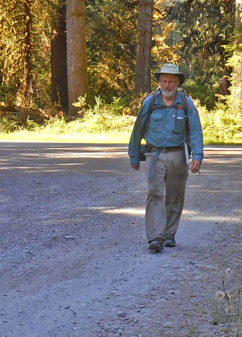
On Sunday after church, Katy drove me to Port Angeles where I got my permit at the Park Wilderness Information Center. We picked up a sandwich to eat and the trailhead and Katy got this photo of me before I headed up the trail at about 6:30 pm.

I hiked to Hume's Ranch as the sun was going down and got there in time to see the sun illuminating a  meadow of golden grass.

I camped below the cabin in a meadow under two big grandfather trees. After dusk I heard some snorting and looked up to see the shapes of two deer feeding in the meadow below me.

In the morning I hiked up to the Elwha bridge that leads to the Dodger Point trail. There's a suspension bridge over the Elwha River that's a nice piece of engineering. Then I hiked back to the Elwha trail and started upriver.

The trail has a surprisingly large amount of elevation gain to get above the Grand Canyon of the Elwha. After Lillian Camp it comes back to the river level.

The beautiful clear waters of the Elwha flowing past the trail near Mary's Falls.

Found this delicate blue eggshell on the trail. 

One of my favorite places in the Elwha is Elkhorn Camp, a beautiful meadow in the middle of the wilderness.

About 3 pm I reached Riemann's Cabin. A plague on the cabin said iot was built in 1926 by Grant Hume (of Hume's Ranch) for  Mr. Riemann, an attorney and judge from Tacoma who used to come every year for a big fishing expedition. The cabin has exquisite workmanship.

The Elwha River and the sun going down on the ridge above Riemann's Cabin.

Near my camp at Riemann's Cabin.

Preparing for dinner at my campsite. Three young guys came in near dark and camped nearby.

On the second day of my hike, I traveled through endless tall forests alongside the Elwha River. I got an early start and hiked for hours in the cool morning air with shafts of sunlight streaming through the trees.

It's impossible to show the height of the trees along the Elwha River. They soar high into the air, probably 200 feet tall or more. Awe-inspiring.

A nice piece of trail work.

The tree behind me is at least five feet in diameter.

About 3 pm I arrived at Chicago Camp. I was pretty well worn out, so I took a nap and read from my book, Gilead by Marilynne Robinson. It's the fictional journal of John Ames, a congregational minister, writing in 1956 at the age of 76, to his son who is 7 years old. The book is very Old Testament-ish. Ames is an Abraham-type figure, writing about his family history (his father and grandfather were also Congregational ministers). At the same same time a drama unfolds involving his godson, and secrets are revealed. I really enjoyed the book, especially considering my great-grandfather and great-great-grandfather were Congregational ministers. I rationed the number of pages I could read each night so I didn't finish too quickly, and as a result re-read some passages.

Elwha Basin
On day three I got up early and made a side hike to Elwha Basin, about three miles. When I got to the Basin, I could see up to the alpine ridges of Mt. Queets and Mt. Noyes. Returned to my pack at Chicago Camp and started up to Low Divide.

I thought that I would have to ford the river at this point, but this tangle of blowdown trees provided a way to cross without getting my feet wet.

After I crossed the river, I was walking across the river stones when I felt a sharp pain in my right calf. I had torn this muscle two weeks earlier, and now I re-injured it. I stopped and massaged my calf, but eventually I had to start up the trail, trying to baby my right lower leg. The trail up Low Divide is steep, and I went slowly, taking lots of short breaks to catch my breath and give my leg some rest. I had lunch about halfway up. By 2:10 I was at the top and got to look back at the Elwha River watershed.

Looking back at the Elwha River watershed.

The huckleberry bushes were loaded with berries. Luckily I didn't run into any bears.

Lake Margaret at the top of Low Divide. I met elevn Boy Scouts and their leaders on their way to go swimming in the lake. I also passed eight young hikers crossing the divide, as well as a few more hikers. A crowded place.

Proof that I made it!

I made my camp at the edge of a meadow, right next to the Boy Scouts' camp, and read my book while my muscles recovered. After dinner I chatted with the scout group for a little bit. They were a Mormon troop from Auburn. 

Sunrise from my sleeping bag.

By 7 am on Day four I was hiking down from Low Divide to the Quinault River. By 9:30 I arrived at Sixteen-Mile camp where I had to ford the river. I took off my boots and put them back on without socks to cross the river. It came about halfway to my knees. I was glad it wasn't any deeper. After crossing, I put my dry socks back on with my wet boots. It wasn't too uncomfortable. Having a pair of good wool socks helped a lot.

Lunchtime found me at Elip Creek, where I ate my lunch and took a nap on my foam pad. So tired at this point.

I kept walking down the Quinault River. This side of the mountains is a lot different from the Elwha valley. The Elwha is long and gradual, but the Quinault is a catacysm of erosion, blowdown and crashing streams. The trail is good, though, and I made good time, arriving at Wolf Bar by late afternoon.

The Quinault River near my campsite at Wolf Bar, with the sun going down. A couple of young guys camped near me.

On Day five, I got started by 7 am and made it to the trailhead just after 8 am. 

This quaint old ranger station is near the trailhead.

 I hiked down the road in the cool early morning air.

Wearily making miles on the road.

I finally hitched a ride with a lovely young family in a tiny Volkswagen station wagon. They stopped when they saw me and apologized, "We're full," but a moment later they stopped again and said, "We think we can squeeze you in." the wife got in the back seat with their two young children, maybe six and four, and I held my pack on my lap. They were from California, traveling up the West Coast, stopping at all the National parks. The kids were so much fun, chiming in with their little voices. What a treat.

They dropped me off at Amanda Park, where I caught the bus to Aberdeen. I caught a quick eye-full of rural poverty while waiting for the bus and riding to Aberdeen. Greasy-haired bikers, haggard old ladies with Appalachian faces, Native American kids with big sneakers, overweight moms with kids in tow. Aberdeen is a post-apocalyptic town with decaying industrial buildings, empty storefronts, and the scary-looking homeless people in the downtown area. I walked to Safeway, got a Starbucks coffee and a copy iof the New York Times, and waited at the transit center for the bus to Olympia.

At the transit shelter in Aberdeen.

In Olympia, I had time to kill while waiting for Katy who was caught up in nasty Friday-afternoon traffic. I walked around downtown Olympia and hung out with the homeless people in the city park.

Olympia City Park

When Katy picked me up, we went to Darby's Cafe and celebrated the end of great hike with a sandwich and beer.